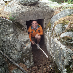
Saturday July 19th marked the official launch of our new project
to play a campaign in the Spanish Civil War with Chain of Command. And no
better way to start the project than visiting one of the battlefields next to
Madrid (El Alto del León) during the morning, followed by a nice lunch and a
game in the afternoon with the first painted minis… and almost coinciding with
the 78th anniversary of the start of war (18th July,
1936)!
Background
Around 60 km north of Madrid, El Alto del León (1,500 mts height) is a key
mountain pass of the road linking Spain’s capital with some of the main cities
of the former Old Castilla region in the north (Avila, Segovia, Salamanca or
Valladolid) and leading into the north-western region of Galicia.
Today it is a secondary road, as between the early 60s and 70s two toll
tunnels and a motorway were dig underneath, facilitating the road
communications between the two halves of Spain. However in 1936, el Alto del
León was one of the three key mountain passes to reach Madrid from the
North (the other two being Navacerrada and Somosierra, the latter also a site
of a famous battle in the Napoleonic wars).
The site saw some important action since the early days of the war when the
summit was occupied a group of the Republican militia on 19th July,
but were attacked and defeated on the 22nd by a Nationalist column
(comprising army units and Falangist militia) coming from Valladolid. The
attack was initiated from San Rafael and had the objective of conquering
Guadarrama at the foot of the mountain where the pass is located. The
Nationalist conquered and hold the pass but could not make any further progress
and the Republican set their line around the Tablada hospital, 3 km down the
summit approximately
 |
| Aerial view of the battle area with Google Maps |
Several attacks and counterattacks followed during the rest of July and
August, but none of the two sides achieved a decisive breakthrough. From
September 1936 the focal point of action moved to the south-west of Madrid,
where the Nationalist columns from Andalucía were advancing towards Madrid,
taking Toledo and breaking the siege of the Alcázar.
The stabilization of the front in this area and the relative lack of
activity at El León gave the Nationalist forces time to build and reinforce the
defenses, which were regularly improved and extended in the following years.
From the winter of 1936-1937 until the end of the war the battle lines won in
the summer of 1936 hardly changed and the opposing forces just kept an eye one
on the other from the system of trenches and bunkers where they took shelter.
The visit
In this visit we concentrated on the Nationalists lines because of their
easy access and better preservation; we´ll likely organize another visit in the
future to the Republican lines, in any case after the summer break.
We explored two areas: La Sevillana and Cabez Líjar (the latter also known
as “La Loma de los Falangistas) located to the left and the right of the
mountain pass summit respectively.
This post will be focused on La Sevillana, that was the main defensive position in the area, extending for
over a kilometer around the main peak (La Sevillana). You can discern the existence
of three main lines:
- A first outer line
- A main defensive position located on the summit of the Sevillana hill
- A set of shelters of different size that can accommodate from 2-3 sections to a full company
The outer line was placed in the slope overlooking the
road to Guadarrama and comprised several positions made of stone walls,
foxholes, trenches and small bunkers. A dominating feature was a bunker
excavated in the rock and whose purpose was clearly to be used as an observation
post (not clear to us whether to direct artillery fire or to watch potential
enemy formations attacking.
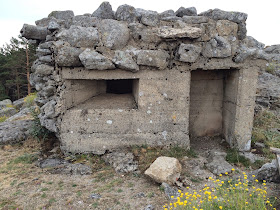
This is a small bunker placed in the downward slope and about a 200 meters from the obervation post. It belong to a long extended position made of stonewalls, trenches and one-man foxeholes. Given the size of the bunker, it can accomodate 2-3 men and probably it was used to place the section`s LMG (?).
 |
| Bunker front |
 | |
| Rear access door |
 |
| Stonewall or parapet |
 | ||||
| Small shleter or foxhole? |
This photo was made from inside the bunker: you may be surprised by the lack of visibility with so many tress interefering the line of fire; these were planted in the 60s and 70s as a part of a massive program to reforest the Guadarrama area and they did not exsit at the time of the war.
It was difficult to captutre in the photos, but going down the slope a few meters from the bunker we bumped into the road leading to El León. Incidentally, the slope was truly steep and if I were to wargame this battle it will crearly copunt as very difficult terrain fro anyone attempting to climb cross country.
 |
| Trench line remants, reinforced with stone |
 |
| Communication trench leading to a small shelter (observe a large stone fallen in the trench) |
 |
| Shelter (for a squad?) |
 |
| 1-man foxhole |
 |
| Another foxhole |
This bunker was so well camouflaged among the rocks that we almost missed it! Similar size to the previous bunker, probably used by an LMG team.
Our next stop was in the summit of La Sevillana, where the main position
was placed. The area is dominated by the two bunkers erected on top of the rock
formation; around this rock there were remnants of stone walls and trenches
excavated in the stone. Behind the position (overlooking San Rafael, we saw a
lot of well constructed stone buildings: commanding posts? Shelters?
 |
| Bunkers on La Sevillana summit |
 |
| Climbing to the top |
 |
| Observe the wall to protect the occupants from moratr shells |
The building in the rear of the position:
In the next post we will visit Cabeza Líjar.


Great post! Considering an SCW project myself, these posts will be really useful.
ReplyDeleteVery inspiring pictures and thanks for all the explanations. I'm really surprised how well concealed those bunkers are.
ReplyDeleteMe too! We are not sure we saw every surviving construction; we spent a lot of time jumping from rock to rock looking for more
DeleteBrilliant! Thanks for sharing this. I am looking forwards to reading the next instalment.
ReplyDeleteFantastic post! Really useful pictures to represent the terrain and fortifications. It is a very good idea from you "to rescue" these elements of our battlefields.
ReplyDeleteExcellent post and very interesting. The then and now photo is a nice touch. What does the monument itself commemorate?
ReplyDeleteThe construction of the mountain pass at the time of the king Fernando VI (1746-1759). Under the lion´s paw you can see two spheres which is symbol of the Spanish empire domination on the two worlds (the Old and the New)
DeleteThank you for this very interesting piece of history, Benito. It must have been backbreaking work in that rocky country to dig out some of those positions, probably with little more than picks and shovels. I'm guessing there wasn't a lot of artillery used in this sector but any shell exploding on that ground would have generated stone splinters as well as shrapnel and fragments, so one can see the advantage to those bunkers and shelters.
ReplyDeleteYou're totally right. Specially the Republican forces lacked artillery at the very beginning of the conflict and most important, trained officers. The calibers were very samll (50/75 mm) and did not cause much damage. What was more critical if you read the contemporary memoir books was the use of aircraft
DeleteGreat photos and a very interesting campaign project. Really enjoy your photo journal. The "then and now" photo of the memorial is quite striking how little the area has changed in 80 years. Looking forward to seeing this project develop.
ReplyDeleteFabulous post Benito! I find it fascinating how forested the area has become. I'm sure most of those bunkers has murderous fields of fire at the time...
ReplyDelete